Site Scan Flight for ArcGIS 4.6.1
Free Version
Publisher Description


Site Scan Flight for ArcGIS makes it easy to collect accurate, high-resolution maps and 3D models using drones.
The app is connected to the Site Scan Manager web application and ArcGIS Online, allowing you to import base maps, saved flight plans, overlays, and previously captured orthomosaics for precise flight planning. Use your ArcGIS Online credentials to log in to Site Scan for additional security benefits, such as leveraging your organization-specific login method.
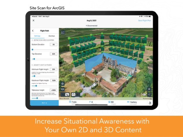
Choose from a variety of flight modes tailored to the type of site being scanned, and the app will automatically define the optimal flight path and allow you to preview it in 2D or 3D. Experienced pilots can use Terrain Follow, which enhances imagery quality by adjusting the drone's height to follow the terrain.
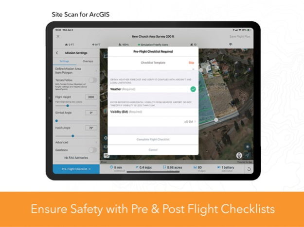
After completing your company preflight checklist, the app automatically conducts aircraft checks and executes the flight. Long flights are automatically split, allowing you to change your drone’s battery and resume where you left off. After completing the flight, wirelessly transfer the images to your iPad and upload them along with your Fleet Management information to Site Scan Manager for processing on the cloud.
Compatibility:
Requires compatible drone: Freefly Astro, DJI P4 Advanced, DJI P4P, DJI P4P V2, DJI P4 RTK, Mavic Pro, Mavic 2 Pro, M200 series, M200 series V2, Inspire 2, M300.
Check the latest documented drone matrix for supported firmware versions.
Requires a paid Site Scan for ArcGIS license.
Jan 18, 2024
Version 4.6.1
- Resolved preflight system check issues for Freefly Astro
- iOS 17 support
- Improved photo estimation
- Airspace link service fix
- Minor bug fixes
Known issues
- Mission recovery issues were found on firmware from DJI M300 RTK v06.01.01.00 and v07.00.01.00 that affect in-app pause action, mission progress, and data capture.
About Site Scan Flight for ArcGIS
Site Scan Flight for ArcGIS is a free app for iOS published in the Office Suites & Tools list of apps, part of Business.
The company that develops Site Scan Flight for ArcGIS is ESRI. The latest version released by its developer is 4.6.1.
To install Site Scan Flight for ArcGIS on your iOS device, just click the green Continue To App button above to start the installation process. The app is listed on our website since 2024-01-18 and was downloaded 17 times. We have already checked if the download link is safe, however for your own protection we recommend that you scan the downloaded app with your antivirus. Your antivirus may detect the Site Scan Flight for ArcGIS as malware if the download link is broken.
How to install Site Scan Flight for ArcGIS on your iOS device:
- Click on the Continue To App button on our website. This will redirect you to the App Store.
- Once the Site Scan Flight for ArcGIS is shown in the iTunes listing of your iOS device, you can start its download and installation. Tap on the GET button to the right of the app to start downloading it.
- If you are not logged-in the iOS appstore app, you'll be prompted for your your Apple ID and/or password.
- After Site Scan Flight for ArcGIS is downloaded, you'll see an INSTALL button to the right. Tap on it to start the actual installation of the iOS app.
- Once installation is finished you can tap on the OPEN button to start it. Its icon will also be added to your device home screen.
